Quantifying Agglomeration and Dispersion Forces
Economic activity is highly unevenly distributed across space. In the United States, the 2,000 counties with the lowest employment densities account for over 75 percent of land area but less than 12 percent of employment. By contrast, the 100 counties with the highest employment densities make up around 40 percent of employment but less than 2 percent of land area. A fundamental research question in economic geography is the extent to which this uneven distribution of economic activity reflects differences in location fundamentals, such as natural resources, mountains and navigable water, or agglomeration forces, such as knowledge externalities.
Understanding the strength of agglomeration forces and of corresponding dispersion forces is central to a range of economic and policy questions. These forces influence economic efficiency, the size distribution of cities, and the organization of economic activity within cities. They have implications for the level and distribution of income and for local and aggregate productivity. They also determine the impact of public policy interventions, such as transport infrastructure investments, local taxation, and regional development programs.
Although the literature on economic geography and urban economics dates back at least to the work of Alfred Marshall in the late 19th century, separating agglomeration and dispersion forces from variation in location fundamentals remains challenging. While high land prices and levels of economic activity in a group of neighboring locations are consistent with strong agglomeration forces, they are also consistent with shared amenities that make these locations desirable places to live or common natural advantages that make these locations attractive for production.
This challenge has both theoretical and empirical dimensions. From a theoretical perspective, to develop tractable models of location choice, much existing research makes simplifying assumptions such as a small number of symmetric locations, which ignores the important differences in location fundamentals that are observed in practice and limits the usefulness of these models for empirical work. From an empirical perspective, the challenge is to find exogenous sources of variation in the surrounding concentration of economic activity to help disentangle agglomeration and dispersion forces from variation in location fundamentals. Part of my research program has sought to overcome these challenges and quantify the magnitude of agglomeration and dispersion forces.
The Costs of Remoteness
In the presence of trade costs, the location of agents relative to one another in geographic space determines their access to one another's markets, which in turn affects consumption, production, and income. Anthony Venables and I used a theoretical model of economic geography to derive theoretically consistent measures of market access that can be structurally estimated using observed bilateral trade data between locations.1 As predicted by economic geography models, these measures of market access are strongly correlated with the observed cross-sectional distribution of economic activity.
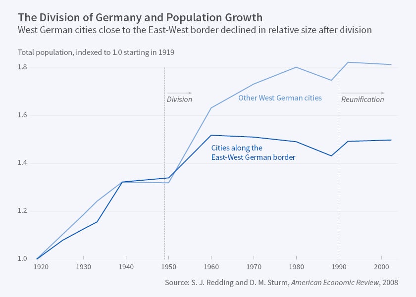
To provide evidence for a causal role of market access, Daniel Sturm and I used the division of Germany after the Second World War and the reunification of East and West Germany in 1990 as a source of exogenous variation.2 The key idea behind our empirical approach is that the division caused West German cities close to the former border between East and West Germany—"treatment cities" within 75 kilometers of the border—to experience a disproportionate loss of market access relative to other West German cities, our "control cities." The reason is that West German cities close to the East-West border lost nearby trading partners with whom they could interact at low transport costs prior to division. In contrast, the effect on West German cities further from the East-West border was more muted, because they were more remote from the trading partners lost, and therefore already faced higher transport costs prior to division.
In line with the predictions of a standard new economic geography model, the imposition of the East-West border led to a sharp decline in population growth of West German cities close to the border relative to their further-from-the-border counterparts. Over the 40-year period of division, border cities experienced a relative decline in their annualized rate of population growth of 0.75 percentage points. This resulted in a relative shrinkage of these cities by about one-third over the four decade division, as shown in Figure 1. In the new economic geography model, the impact of division is determined by two parameter combinations: the strength of agglomeration and dispersion forces, and the elasticity of trade with respect to distance. We show that for plausible values of these parameter combinations, the model can account quantitatively for both the average estimated treatment effect of division and the larger estimated treatment effect for smaller cities that are more dependent on markets in other cities. We also provide evidence against a range of potential alternative explanations, such as differences in industrial structure, differences in the degree of disruption during and in the aftermath of the Second World War, Western European integration, and fear of further armed conflict.
My more recent research has explored how factor mobility across locations influences the welfare gains from trade in goods.3 In an entire class of trade and geography models, I show how observed data on bilateral trade between regions, population shares, and income shares can be used to undertake model-based counterfactuals for the welfare effects of transport infrastructure improvements and other public policy interventions. Within this class of models, changes in each region's share of trade with itself and its share of mobile factors of production provide sufficient statistics for calculating the welfare effects of changes in trade costs.
The Economics of Density
Agglomeration and dispersion forces not only determine the distribution of economic activity across cities and regions but also play an important role in shaping the internal organization of economic activity within cities. To quantify this role, recent research I have undertaken with Gabriel Ahlfeldt, Daniel Sturm, and Nikolaus Wolf develops a structural model of internal city structure that incorporates both agglomeration and dispersion forces and an arbitrary number of heterogeneous locations, while remaining tractable and amenable to empirical analysis.4 Locations differ in terms of productivity, amenities, density of development (which determines the ratio of floor space to ground area), and access to transport infrastructure. Productivity depends on production externalities, which are determined by the surrounding density of workers, and production fundamentals, such as topography and proximity to natural supplies of water. Amenities depend on residential externalities, which are determined by the surrounding density of residents, and residential fundamentals, such as access to forests and lakes. Congestion forces take the form of an inelastic supply of land and commuting costs that increase with travel time, where travel time in turn depends on the transport network.
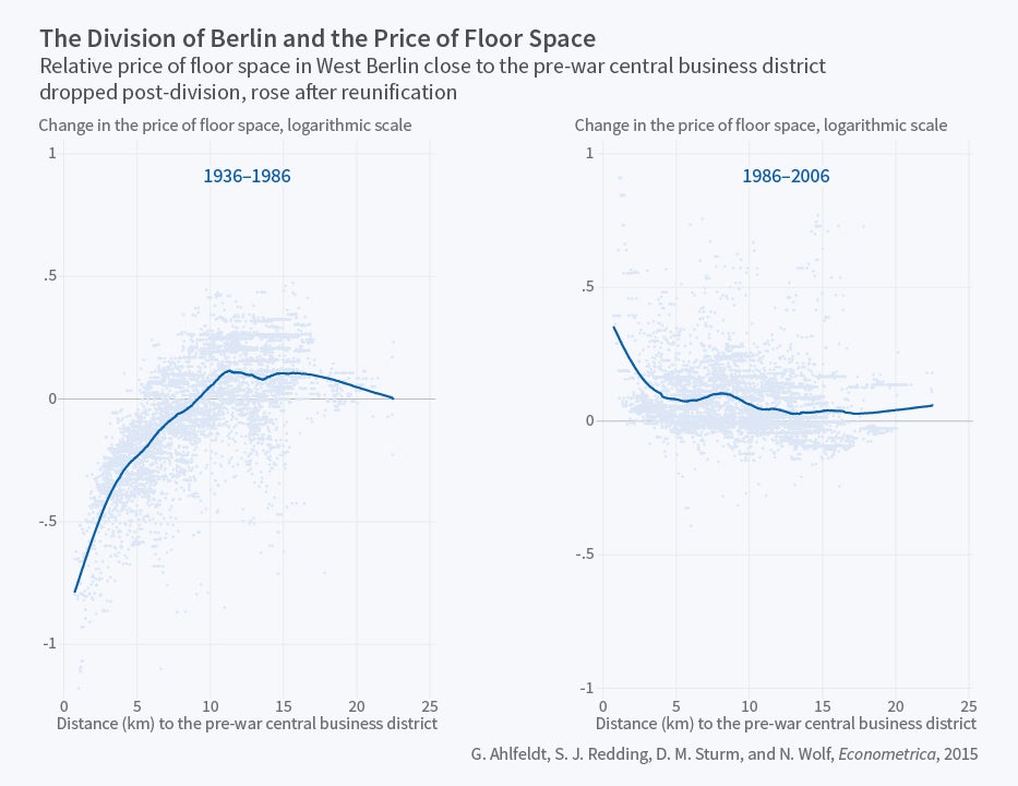
We combine this quantitative urban model with the natural experiment of Berlin's division in the aftermath of the Second World War and its reunification following the fall of the Iron Curtain. The division of Berlin severed all local economic interactions between East and West Berlin, which corresponds in the model to prohibitive trade and commuting costs and no production and residential externalities between these two parts of the city. Our analysis makes use of a remarkable and newly collected dataset for Berlin on around 15,000 city blocks, which includes data on land prices, employment by place of work, and employment by place of residence covering the pre-war, division, and reunification periods.
We first present reduced-form evidence in support of the model’s qualitative predictions without imposing the full structure of the model. We show that division leads to a reorientation of the gradient in land prices and employment in West Berlin away from the main pre-war concentration of economic activity in East Berlin, the prewar central business district in Mitte, while reunification leads to a reemergence of this gradient as shown in Figure 2. In contrast, land prices and employment show little effect of division or reunification along other, more economically remote sections of the Berlin Wall.
We next use the exogenous variation from Berlin's division and reunification to structurally estimate the model's parameters determining the strength of agglomeration and dispersion forces. Our identifying assumption is that the systematic change in the pattern of economic activity in West Berlin following division and reunification is explained by the mechanisms of the model—the changes in commuting access and production and residential externalities—rather than by systematic changes in production and residential fundamentals. We find substantial production and residential externalities, with estimated elasticities of productivity and amenities with respect to the surrounding density of economic activity of around 7 and 15 percent respectively. Both externalities are highly localized and are estimated to decline to around zero after nine minutes of travel time, about half a kilometer of distance for our estimated average travel speeds.
Undertaking counterfactuals for the impact of division and reunification, we show that the special case of the model without any production or residential externalities is unable to account quantitatively for the observed reallocations of economic activity within the city. In contrast, for the estimated values of production and residential externalities, the model is successful in matching the observed impacts of division and reunification, both qualitatively and quantitatively. Therefore, using the exogenous changes in the surrounding concentration of economic activity from division and reunification, we find that strong and highly localized agglomeration forces are central to explaining the observed changes in internal city structure.
Broader Research Agenda
My broader research agenda remains concerned with quantifying the magnitude and implications of spatial interactions between locations. Past research with Sturm and Wolf has provided evidence of the role of such interactions in generating path dependence or multiple steady-states in location choices.5 Current research with Ferdinando Monte and Esteban Rossi-Hansberg demonstrates the importance of spatial interactions between locations, in particular through commuting, for understanding the local economic impact of labor demand shocks.6 Ongoing work with Pablo Fajgelbaum quantifies the role of internal geography in shaping the effects of external integration, using the natural experiment of Argentina's integration into the world economy in the late-19th century.7
All of these papers are part of a broader, developing literature on quantitative spatial models, which are rich enough to incorporate first-order features of the data and also tractable enough to be amenable to counterfactual analysis. In a recent survey paper with Rossi-Hansberg, we review this rapidly-growing literature and the many exciting areas for further research.8
Endnotes
S.J. Redding and A.J. Venables, "Economic Geography and International Inequality," Journal of International Economics, 62(1), 2004, pp. 53–82.
S.J. Redding and D.M. Sturm,"The Costs of Remoteness: Evidence from German Division and Reunification," American Economic Review, 98(5), 2008, pp. 1766-97.
S.J. Redding, "Goods Trade, Factor Mobility, and Welfare," NBER Working Paper 18008, April 2012, and Journal of International Economics, 101(c), 2016, pp. 148-67.
G. Ahlfeldt, S.J. Redding, D.M. Sturm, and N. Wolf, "The Economics of Density: Evidence from the Berlin Wall," NBER Working Paper 20354, July 2014, and Econometrica, 83(6), 2015, pp. 2127-89.
S.J. Redding, D.M. Sturm, and N. Wolf "History and Industrial Location: Evidence from German Airports," Review of Economics and Statistics, 93(3), 2011, pp. 814–31.
F. Monte, S.J. Redding, and E. Rossi-Hansberg, "Commuting, Migration, and Local Employment Elasticities," NBER Working Paper 21706, November 2015.
P. Fajgelbaum and S.J. Redding, "External Integration, Structural Transformation, and Economic Development: Evidence from Argentina 1870–1914," NBER Working Paper 20217, June 2014.
S.J. Redding and E. Rossi-Hansberg "Quantitative Spatial Economics," NBER Working Paper 22655, September 2016, and forthcoming in Annual Review of Economics.